2019-10-12/13 (Saturday/Sunday)
Another boring blog with no photos, I am afraid. These days driving on the highway are not that picturesque—or maybe we’ve just stopped noticing all the things that are “different”. But Saturday was a very nice day, breaking up our drive home (which is basically what our travels have become now.) We had to drive about 5 hours from the Indiana border (western, that is) to central Ohio. So we stopped for lunch at Arby’s, but otherwise were trying not to waste any time. We wanted to get to our friends, Gary and Jan, by 3:30 if possible for the kickoff of the MSU game. (Gary is, sadly, an Ohio State Uber-fan, and last week we exchanged some unpleasant text messages as his team pummeled mine. But the rest of the year, he is fine rooting for the Spartans.)
We sadly got stuck in some serious traffic outside of Indianapolis, so we didn’t make it to Gary’s local Walmart before the game started. Luckily, he taped the game so we could pick it up whenever we got there. We drove to Walmart, and he met us there so that we didn’t have to unhook the Jeep to drive to his house.
We had an absolutely lovely time with our friends, despite the worst loss that MSU has suffered in years. I am going to have to stay away from paying ANY attention to football all week, because the articles online are just horrifying to read (the game was horrifying to watch.) Luckily, we had friends to divert us (me) from misery. We caught up with our lives, our children and grandchildren news, and all kinds of other stuff. We are really very fond of them, and it is great that our travelers take us through central Ohio with some regularity so we get to keep up. I think we last saw them in May of 2018, on our way to Wisconsin.
At about 9:00, after a delicious dinner, we hugged Jan goodbye, and Gary brought us back “home” to the Walmart. Joe went right to sleep, but I was sitting and reading, with our new propane heater on to alleviate the chill. The darn thing set off the carbon monoxide detector, which required Joe to get up and the two of us spent some time wafting fresh air into the RV. We didn’t think the heater would cause that to happen; we had a baby one that was fine, but Joe bought this new one which is more powerful, and we’ve only used it twice. This was just a surprise.
Once that excitement ended, I went to bed and slept VERY soundly, until 8 this morning! And then, all we did was drive. I drove the first two hours, passing Columbus and almost to the border before we stopped for some lunch at a rest stop. Then Joe drove us through the West Virginia panhandle into Pennsylvania.
We stopped tonight at a Pennsylvania State Park where we’ve stopped before, quite early for us— 4:30, I think. We wanted to take it easy. Plus it is 30 miles from where we want to go tomorrow, before we finish the drive home. I remembered one place that I’d wanted to see last year, and we didn’t quite manage it—so we are going to have one more “experience” before we get home tomorrow evening.
Sunday, October 13, 2019
Friday, October 11, 2019
Rain, Pappy’s, and Driving Some More
 |
| Joe points to George Takei’s menu |
It rained a lot early this morning, and before bedtime last night too. Not sure I mentioned it in last night’s blog, but with all the rain, we discovered we have a leak over our bed where Joe replaced the old, non-working exhaust fan this summer with a new one. There was definitely a very damp spot in the ceiling before we fell asleep, and it was notably larger when we woke up. This is not good news, and will have to be dealt with asap (but not before we get home.)
We left our very damp campground at about 10 as usual, and noted that every river we passed in the vicinity was overflowing. Wow, it was wet everywhere! But we were fortunate that it didn’t rain at all today while we were driving. It was just gray skies all day, that’s all.
We stayed off the interstate as long as possible, rejoining it about 30 miles from St. Louis. Then we gave ourselves a treat—we drove into the city to have a late lunch at Pappy’s Smokehouse. Pappy’s was voted the best ribs in the country by the Food Network, and I think Joe agrees. However, today he didn’t have ribs, he had a pulled pork sandwich, while I had my usual, the BBQ pulled chicken. I even have notes on my phone to remind myself not to bother ordering the brisket, because the chicken is “that good!” Seriously yummy— we really enjoyed it!
 |
| Inside Pappy’s— walls lined with celebrity menus |
 |
| Folks waiting on line at Pappy’s. Sometimes the line is out the back door. |
Anyway.... that was our excitement for the day. After lunch, back on the I-70,and we zoomed past the St. Louis Arch, over the Mississippi River, and into Illinois. We planned to stop at the Illinois side of the border with Indiana, but the Walmart we went to, despite getting good “overnight reviews” on our RV Parky app, told us (when we asked inside) that we couldn’t stay there. So we had to drive another 25 miles or so into Indiana, and we are staying at a Walmart in Terre Haute. We were tired and not very hungry when we got here, so we “hung out” a little bit, and now we’re going to sleep. We want to make a reasonably early start tomorrow, because we are heading to visit Jan and Gary in Ohio, and watch the football game with them.
Thursday, October 10, 2019
Driving Driving Driving
2019-10-10 (Thursday)
We’be sure been having a lot of weather lately. For several days, we were driving under cloudless blue skies through Nevada and Colorado. Yesterday afternoon we finally noticed clouds had arrived, but it was still a HOT day (in the 80s). Except by the time we parked, it was getting a bit breezy. The temperature didn’t drop too much overnight-it was about 60 when we woke up this morning—but we had wind through our open windows all night, and it seemed to be really whipping up in the morning.
As we dressed and had breakfast, we were pretty worried about driving—the wind was rocking our RV noticeably. We are nothing but a big box on the highway, when all is said and done, and driving in high winds is pretty scary if not downright dangerous. We checked all the weather reports locally and ahead of us on the road, and were somewhat alarmed at mentions of a storm front, and severe rainstorms in central Missouri, our destination for the day.
Finally we decided to go as far as Wichita, only an hour away, and see what the current reports were. We got on the road at 8:45 (early!!!!) and were happy to not feel buffeting as we drove. In fact, the wind seemed to be at our back. By Wichita, there was nothing to note that was alarming, so we kept on driving. We adhered to a strict one-hour schedule, taking turns, because it was a pretty monotonous road, and hard on the eyes.
That was pretty much the sum of our day— taking turns driving. The sky was overcast most of the day, although it seemed we were headed toward slightly lighter clouds. We stopped in Eureka, Kansas, for lunch. We drove down a side street to the local park, where we were the only people to be seen. Cassie appreciated the grass very much. Then we drove on. At about 2:00, we crossed the state line into Kansas (I was driving and Joey didn’t get any photos for me). And still things were going smoothly. We made good time on US-54, still going due east.
As the afternoon wore on, we projected where we might be able to stop, and ended up finding a town near the Lake of the Ozarks, which seems to be an enormous reservoir, judging by all the irregular edges. After two nights at Walmart, we voted for showers, so I used my Good Sam app and found a nice campground in the town of Osage Beach.
Just as we checked in, we heard lots of loud thunder, and by the time we reached our assigned site, it was raining cats and dogs. It has been raining most of the evening since. Not only that, our phone weather alarm apps both went off a few minutes ago, warning of flood alerts in this area. Poor Cassie does NOT like this weather—she has been shoved under the kitchen table for a while to stay safe, although she has now come out as the rain lessened a bit.
The report is that it will rain all night, and early in the morning. There are all kinds of random threats to go with it, such as nickel-sized hail and even tornadoes. Usually nothing like that really happens, though, so I’m not too worried, but I hope it stops before it’s time for us to really start driving. We are heading toward St. Louis, and then into Illinois, and will be forced to take the interstate sometime during the day. We are so glad to have stayed off it until now; it’s difficult driving with all the trucks blowing us around. We’re happier taking our risks with Mother Nature. Our worries about the high winds this morning turned out to be nothing, and I’m sure I’ll sleep just fine tonight.
Wednesday, October 9, 2019
We're Back in Kansas, Toto
2019-10-09 (Wednesday)
As exquisite a day for scenery as yesterday was, that's how bland today was. It's a bit of a difficult transition to drive from Colorado to Kansas, and that's just the truth.
We had a good night at the Walmart lot in La Junta, Colorado, and woke up expecting to get a pretty early start. We WOULD have gotten out before 9:30 (that's early for us!), but I noticed after I walked the dog that I couldn't find my phone. Joe was helping a neighbor--an older woman on her own in a large RV who couldn't get her generator to start, and I was cleaning up our RV, and then I realized I didn't see my phone.
I had actually thought I'd taken it out with me when I took Cassie out, maybe 30 minutes earlier, and I realized before the walk was finished that I didn't have it. I assumed I hadn't really taken it-- I mean, it would have been in my shirt pocket, which is hard to lose something. But I got Joe to come help me, and we spent an hour searching for the phone both in the RV and combing the area where I'd walked. The Life 360 app on the phone said it was still where we were, but we were stymied. After an hour, I went into the Walmart to ask if by chance, someone had found a phone. It seemed like a long shot, but.... YES! They had my phone! So I guess miracles CAN happen.
After that, we got going pretty quickly, but it was already something like 11:00ish. The roads in the eastern park of Colorado are not very fascinating, although the southeast corner where we were today sure beat the I-70 corridor we took last year, which we thought was pretty much unsurpassed for drabness. At least we passed through some small towns.
Just at the state border, there was a rest area, and we stopped there for lunch. We were also happy that they had a dump, because we'd felt perhaps we needed that particular facility. So it was a reasonable stop, except I was somewhat in despair that we were still not even out of Colorado, and it was about 2pm when we left the rest area.
Luckily, the rest of today's drive was less dilatory. The only issue was the significant wind we encountered in Kansas a bit before Dodge City, through tonight when we stopped at Pratt, Kansas's Walmart. (Joe says one thing he likes about this campground is "No quiet hours," ha ha!!) Anyway, I drove the last 80 miles, I think, and the wind was something not fun to deal with. The road was a 65mph road, but that was too fast to drive; I stuck to about 60 instead.
We got to Walmart just at sundown, having made 299 miles (our goal for the day is 250-300 miles.) We had dinner, and I thought we had a long evening ahead, but we just figured out, we are now in the Central Time Zone. So we are only one hour behind home now! Oh, we did have to leave US-50, our road since Reno; US-50 wants to join up with an interstate highway soon, and we'd like to avoid that as long as possible. So we plan one more day on the "blue highways."
No photos today--I was driving a lot, and there was really nothing exciting to photograph. We did note the fields of sorghum, which were impressive, but otherwise nothing really exciting. We were beside the Arkansas River all day, but it seems to peter out in Kansas, and the bed was pretty dry a lot of the time. So... no scenery. It's just Kansas. As we passed through a small town somewhere, there was a sign at the far end of town: "I'd turn back if I were you!" We laughed, but besides that fact that that's an OZ warning, and we were still in Kansas, it's no joke. If we could turn back to Colorado, we just might do that! Except, I have to admit, I miss my babies! So Eastward Ho tomorrow!
Tuesday, October 8, 2019
Colorado US-50
 |
| Along the Gunnison River |
We woke up to an exquisite morning at 8,000 feet-- a blue dome of a sky uninterrupted by a single cloud, crisp mountain air, and the colors of fall all around us, reds, yellows, and rusts (plus evergreen, of course.) I guess that was invigorating enough that it got us moving a little ahead of our usual departure time.
The Jeep, of course, was not attached to the RV, so we drove down the mountainside with me leading Joe in Samantha. What we got to see was what we'd missed driving up-- the valley below us spread out in an endless vista. Wow, it was spectacular-- but of course, no one could take a photo, because we were both driving. We got to the bottom quickly (a lot easier than laboring up the mountain yesterday), and I soon found a pullout so we could hook the Jeep back up to the RV. And then we were back on the road again.
We are still following US Route 50, which started out in Reno, became the "Loneliest Highway", and now is not lonely, merely beautiful, through most of central Colorado. We had driven on this road before, back in 2015, and I think I must have taken a lot of the same photos back then! We drove through canyons, and past ranch land, but the most beautiful areas were Blue Mesa Reservoir, and the Arkansas River canyon after the reservoir, to the town of Canyon City. Really, it was a lot of "wows" again. The only problem was, it was pretty slow driving, and we were trying to make our "average" of about 275 miles/day so we get home on time.
 |
| Along US 50 in Colorado |
 |
| Blue Mesa Reservoir |
 |
| Arkansas River Canyon |
 |
| Walls of Arkansas River Canyon |
 |
| Me and the Jeep on the Continental Divide, Monarch Pass |
Black Canyon of the Gunnison National Park

Joey and I both slept really soundly last night--so much so that we were quite unprepared when the alarm went off this morning. I personally could have easily slept another hour. But needs must, so we got ourselves together, walked the dog, tweaked something on the tire (I forget what), and left Green River at about 10:00, as usual. Less than an hour later, we were in “Wild, Wonderful Colorado.”
We followed US 50 (which was still twinned with I-70) to Grand Junction, then peeled off toward Delta and Montrose. We had decided to go to the visitor center at the Black Canyon of the Gunnison National Park, look around, and then decide if we were staying or not. We’d gone past the turnoff to the park a couple of times, most recently in 2015. I decided maybe it was time for us to go there, before we really hit the road hard to get home.
We arrived at the turnoff at about 2:30pm, which was what I’d anticipated. What no one had told me about this park was that it is HIGH UP! I knew it was 6 miles after the turnoff from US 50. But almost immediately we began to climb. And climb. And climb. I was driving and we were getting nowhere fast!
 |
| View of Canyon Walls from an overlook |
We arrived at the visitor center a little short of breath, both from the ascent and the 8,000 feet once we arrived. I talked to someone about some ideas, and decided our plans had now changed-- after all the trouble it had been to get up the mountain into the park, we were NOT about to just look around quickly and leave. So we went to the campground and found a nice pull-through site and got ourselves set up there. Then, around 4:30 or so, we took the Jeep on the 7-mile Rim Road which leads to overlooks of the park.
 |
| Very Narrow Canyon |
The Black Canyon is pretty amazing, with its steep dark walls and being so narrow. It is very vertiginous to look down at the various view points, and since the paths tend to slant down to those views, I was constantly feeling a bit off balance. Joe was feeling exhausted, and I was pretty huffy and puffy from the thin air. So we didn’t stop at all of the viewpoints, particularly because most of them required a short hike (300 yards or so) to get to them. We finished up at Sunset Point, and waited until the sun went down. The view of the mountains was very pretty.
All in all, I did not fall in love with this park the way I did at Lassen or Olympic NP. The Black Canyon is really impressive, but to me lacked the same spirituality as Lassen or the beauty of the Olympic Peninsula. So to each his own, I guess... we are glad we came up here, but it’s not a park I think I would return to.
Tomorrow we will head east again on US 50, and I am concerned because I remembered that in 2015, we took this route and crossed the 11,000 foot Monarch Pass. I told Joe, we are going to have to unhook the Jeep yet again after we leave here (we’ll plan to hook up tomorrow morning once we get down the mountain.) Sam made it over the Monarch Pass back then, and we have the photos to prove it, but not pulling a Jeep! At least I remembered ahead of time this time! And after that, we’ll probably be angling up to intercept I-70 again and drive hard through the midwest states. Once we leave Colorado, we’ll officially be in the midwest (Kansas, that is). And we’ll have left the beautiful western states behind us for this year.
 |
| Another View of an overlook with canyon walls beyond it |
 |
| Gunnison River looking west toward mountains and sunset, from Sunset Point |
Sunday, October 6, 2019
Great Basin, and Great Scenery

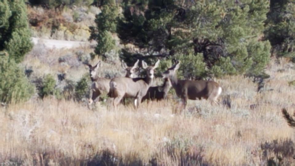
We woke up to blue skies again, and another cold morning. But after getting ourselves all ready to leave Great Basin National Park, we went on a walk first. And that changed our whole perspective of the park! I was just about to take a photo of our truly beautifully located campsite (inconvenient though it was to get into last night), when Joe and Cassie noticed a small herd of deer in the site next to us. They slowly came into sight behind us, and until Cassie barked, they were just going about their business. That was a nice scene.
 |
| There's a deer to the right of the big tree |
Then Joey pointed out the pinyon pine nuts on the trees growing next to us. The park's newspaper specifically says that these nuts can be gathered during their season. Well, it seems this is the season! I gathered two pocketsful of nuts--they will have to be shelled, but still, we got them fresh on the ground right under the tree. There were zillions--the park allows 25 lbs per family per year. I guess there must be millions going to waste, but we will take some home.
Then we followed the sound of a rushing brook, and it was lovely too! Really, it's an inconvenient campground in some ways, but the location is absolutely gorgeous. On our way out, the view of the valley ahead of us was fantastic also.
 |
| Valley view |
The Loneliest Highway continues into Utah--but the mountains come sooner, and are very cool. I have to save my greatest superlatives for later in the day, but I didn't remember that, so I took some photos of the mountains as we went through them. Joe said, "Didn't we drive this road before? I remember this scenery!" And then I remembered, we did-- we drove this same route in 2007!
 |
| Western Utah, US-50 |
Remembering that helped when US 50 finally merged with I-70 in Salina, Utah. The stretch from there to Green River, a bit over 100 miles, has no services at all-- but it is the most spectacular road I've ever driven. I didn't even try to take many photos, because I remembered I took dozens with my good camera in 2007. So I am going to revisit those for this blog and save time, LOL! We even stopped at the same scenic pullout, and took some of the same exact photos (I couldn't resist, after all.) There was an Indian woman with her jewelry and pottery spread out at the pullout, as well, and I bought myself a necklace. It will make me think of that location when I wear it!
Suffice to say that the road was beyond exquisite-- there are not enough superlatives to describe the incredible rock formations and colors that you pass in those 100 miles. Not to mention all the steep climbs and scary descents you have to drive down!
 |
| Teaser: Moon over the Rafael Swell on I-70, Utah |
Heading Out on the “Loneliest Highway”
 |
| View along US 50 |
I woke up today feeling a lot better. I think the chiropractor really helped. I was being careful of how I moved my body, and seemed to be okay. So Joe worked hard to get us all hooked up to leave, when all of a sudden, I got that sharp pain again! Luckily, I lay down and it eased up. I refused to be helpless this time, and put two ice packs on my lower back (where the pain was concentrated this time), and made my way gingerly into the co-pilot seat. We finally left the campground after dumping the tanks, stopped for gas, and hit the road.
And that pretty much describes the day, actually. As I think I already wrote, Highway 50 east of Fallon, Nevada is known as the “Loneliest Highway in America,” for it’s barren appearance and lack of amenities, towns, or even traffic. It certainly lives up to that reputation! We drove and drove, and although it is beautiful in a stark and barren way, there is a lot of NOTHING there! I did take some photos to illustrate it.
And that’s how the day went. We were trying to make it to Great Basin National Park for the night, and after stopping briefly in the town of Ely to get some more water, we drove the last hour knowing that the sun was sinking fast. By the time we got to the visitor’s center, we knew it would be closed—but it was too dark to even read anything without our heavy flashlight. I looked at the map in the kiosk so I knew the general direction, and we drove up a pitch-black road for about 6 miles until we came to the gate of the park. Then we drove carefully, watching for the turnoff to the campground. The turnoff road was 3 miles long and unpaved... it was PITCH BLACK and unpaved and we were driving about 10 miles/hour.
 |
| The road ahead-- US 50. It goes on forever. |
BTW: We drove this same road in 2007. Here is a link to my description back then.
 |
| The view gets prettier and less barren in eastern Nevada |

Leaving Lassen (posted out of order)
 |
| Mount Lassen, seen from scenic overlook |
Our day started very early, as Joe and I awoke hearing a strange clicking noise. He immediately identified it as our gas furnace attempting to turn on; the clicking meant that the battery in the RV was dead. I thought we could manage another hour--it was warm in our sleeping bag--but he is a bit obsessive about taking care of the batteries, which is of course a good thing. But poor Joe, it meant he got dressed and went outside and had to jump the RV battery from the Jeep, and then we had to run the RV engine for about an hour to juice up the batteries again. I felt terrible for the others in the park whose quiet early morning was possibly disturbed, but I suppose they would have understood if they knew we had no heat.
Anyway, the furnace went back on, the engine was turned off, and I think we both dozed off again around 7 a.m., until a little after 8. At which point we heard another odd sound which woke us up. It turned out to be a noise from the radio (which was on?) coming through the speakers over our heads in the bed. That was the final straw, and we decided the RV wanted us to get up. So we did.
Since we were leaving the park this morning (waaahh!!!), we had to hook up the Jeep. We drove a short way to the boat launch near the campground, which was flat and long and almost deserted, so we weren’t in anyone’s way. The hook-up went smoothly. Then I noticed it was about 10 minutes before 11:00. I suggested to Joey that we drive to the Visitor Center (a quarter-mile or so away) and watch the park film which is shown every 30 minutes. I figured we have 45 hours of driving time to get back to New Jersey, so how much difference is 30 minutes more going to make?
We parked and ran into the Visitor Center, getting there JUST in time for the movie. It was very interesting, and gave us a great overview of a lot of the places we’d visited yesterday, plus historical photos and videos of the volcano erupting in 1915. In some ways, I think I got more out of the video seeing it after I’d toured the park, rather than before! Afterwards, I took some time to look at the museum exhibits I’d hardly noticed yesterday morning when I’d stopped in.
Alas, by noon it was really time to stop postponing our departure, and so we headed out. We made a brief stop at the same store we’d bought gas at two days ago, to pick up a couple of cans of propane (our small propane heater was no use this morning, since it too ran out of fuel during the night.) Then we headed toward the town of Susanville. Almost immediately, we saw a sign for the Hat Creek Scenic Overlook, and we took it.
Wow!!! The view was incredible. We had about a 180-degree view of the valley around us, with Mount Lassen in clear view, and Mount Shasta faintly visible in the distance. There were a number of panels identifying the different mountains we were seeing, and pointing out three distinct areas which had suffered from forest fires. The outlines were very clear. But mostly I found that I was having the most elated feeling being up there! I simply felt ecstatic--it was fairly warm (I was only wearing one long sleeved shirt, and the sun was shining), there was a slight but warm breeze, and the air was so clean and revitalizing. Every time I turned toward Lassen Peak, I got another rush!! It is so hard to describe.... I could have stayed up there for hours. As it was, I stood out there for at least 20 minutes, just drinking it in, and staring. Joe also agreed that the landscape was simply extraordinary. I felt so energized and thrilled just standing there. It was so very hard to leave!
Sadly, we continued south-east to Susanville, which turned out to be a cute historical town on the side of the mountain, with a main street sloping down the hill rapidly (a bit like Butte, Montana, actually.) We only could catch glimpses of it, because there was no good place to pull over on such a steep slope. So we went through, and picked up US-295 toward Reno, Nevada. We passed a number of beautiful hills at first, but then the road seemed to become more drab. We stopped to fill the RV’s propane tank, and when I walked Cassie, what looked like grass turned out to be sticker plants low to the ground. The poor thing immediately got stickers in her paws, and we had to dig them out with her. It seemed like a metaphor for leaving such a glorious location behind us.
Soon enough, we crossed into Nevada. It seems that US-295 is also not worthy of a “Welcome to” sign. That’s TWO welcome signs I got cheated out of-- California and Nevada! But even without the sign, we are here. Our sadness at “turning left” to drive eastward was compounded by finding ourselves in a 3-lane each way traffic jam! It was rush hour, of course, and we were stuck in it for a short time before all the traffic thinned out. But it could not have been more the antithesis of our glorious Mount Lassen and Lassen National Forest. Frankly, it was horrible.
Once we were past the main city area, traffic was not bad, and the scenery along I-80 was beautiful rocks again. After we arrived in Fernley, we luckily could leave I-80, since we decided we couldn’t stand to just come home on the Interstate after such a wonderful western experience. Every road has been beautiful since before the end of September! So we are taking US-50, “the Loneliest Road in America”, as it is dubbed, straight through Nevada, Utah, and Colorado. Unless, of course, the weather stops us.
As it is, it was actually gorgeous weather today, warm and sunny and almost mild. We stopped for the night in Fallon, the last “big” town before the Loneliest Road really gets going (there’s nothing for another 100 miles, or more). We’re at the Fallon County Fairgrounds, where we were able to park for $15, including water and electricty. We are in a lot of company, because currently there’s a shooting competition going on here! The guy in the next RV over said he’s not a shooter, he is selling western wear clothing at a booth. We spoke to a guy dressed like Matt Dillon or some other 19th century western denizen of Dodge City, who told us he was in one of the competitions today, and placed 10th out of 48 entries. We are hoping that the event opens again tomorrow before we leave, since that would be quite an unusual event for us to attend! But if so, it will delay our arrival at our next destination, Great Basin National Park. So we will see how the morning goes.
I should add that I do have great photos from today, and fabulous ones from yesterday, but the internet here is not working so well. It is allowing me to update the blog, but not upload photos (or download them, for that matter, into my computer.) So I do hope I’ll have a chance to do that soon. Some of the photos I took yesterday should really be postcards, and the ones of Mount Lassen from lunchtime today are just beautiful. But I’m pessimistic about my connectivity for the next few days, so we will have to see how it goes.
Saturday, October 5, 2019
OW!!!!
2019-10-04 (Friday)
Today was one of those bumps in the road that we just have to swerve around or go over. I hope it all turned out okay (I’ll know better tomorrow.)
The morning was as usual— we woke up to discover that although it had gotten cold overnight, the sky was bright blue and the sun was warming the world up nicely. We were packing up to leave, when suddenly I had a sharp sciatica pain shoot through my hip, down my thigh, and into my back. I was stunned to realize I could barely walk or move into any position at all without pain.
Joey quickly told me to go lie down, suggested some positions to relieve the pain, etc. but nothing helped. At last, he gave me some of his super-meds. One of them took away the pain after a while, but made me definitely dizzy (clearly I was not going to be driving!) The other one was supposed to work on inflammation, the presumed source of the pain. While I lay for a couple of hours resting, he unhooked the Jeep and took it into town, buying supplies he’d need to change the RV oil, and getting the Jeep serviced at a Jiffy Lube in town (town being Fallon, Nevada—we are parked at the county fairgrounds.)
By around noon, however, the meds had worked, and I seemed to have fully recovered. We decided that, since we were in a good place to do so, he should change the RV oil before we actually left. I, meanwhile, was able to walk the dog, and put away odds and ends in the RV. When Joe was done, we had some lunch and once again packed up to leave. But suddenly, just after he’d hooked up the Jeep, I took a step and zoom, pain returned—not as bad as before, but again I had to lie down for a bit.
While I was lying down, Joe decided that we should not drive today—it was already 3pm and obviously I wasn’t doing as well as we thought. Then he suggested calling a chiropractor. He thought that would help. So he did, and found someone who had good reviews on Google, and could take me at the end of her day. So we both rested for an hour, and at 4pm, we drove over-I was able to walk pretty well, but obviously I wasn’t standing straight and I did have pain. I used a step stool to help me get into the Jeep, which I always have difficulty with because it is so high.
The chiropractor turned out to be a lovely woman who spent 30-45 minutes working on getting me straight, applying heat, and doing mysterious things until the end, when she cracked my spine a. Bit straighter. I was definitely standing taller and in a lot less pain when she finished! We gladly paid her very reasonable fee, and I climbed carefully back into the Jeep.
Since we were just across the street from the Safeway, I told Joe we should stop there before heading home. He was a little dubious about me walking, but I felt so much better and didn’t want to waste the chance to pick up the few things we needed. So we got ourselves a couple of bags of groceries, and also stopped at the ATM in the store (I’d paid cash to the doctor, and didn’t have a lot more.) And then we came home.
I crawled into bed, because by then i was feeling a bit drained. Joe made some Mac and cheese for dinner, but we both went to sleep pretty early; it was a stressful day. However, my last thoughts were on the bright side. Thank goodness this happened in a place where we could find the resources we needed; and thank goodness even MORE that it didn’t happen a couple of days earlier, in Lassen, when we’d have had to curtail our visit to the park. I was in physical pain today, but that would have added so much psychic pain to the situation. So hopefully, today, all’s well that ends well, and I’ll be able to drive tomorrow. I think that the hiking on uneven ground, missing my regular yoga class, and not having a massage for a long time, has caught up with me a bit!
Thursday, October 3, 2019
A Peak Experience
 |
| Hat Creek tumbling from Mt. Lassen |
We had a wonderful day today in Lassen Volcanic National Park. We definitely timed it right vis-a-vis those winter storms that came through. There is enough snow here to remind us that winter is coming, and the night was cold--definitely below freezing. We were toasty warm, though, and woke up to clear blue skies without a single cloud all day! Joe said he knew it would be clear... we went out last night, after I finished my blog, to look at the stars. It was gorgeous-- at 5,000 feet elevation in the forests of northern California, surrounded by only tiny towns, there is no ambient light from anywhere. The only thing limiting us was the incredibly tall trees- we looked straight up, and our sky was surrounded by trees. But it was all crystal clear then, and this morning too.
Unfortunately, Joe didn’t sleep well, so I left him to try to take a nap around 10:00, while I went to the visitors center for maps and information. I dawdled there, chatting with not-quite-2-year-old Eloise and her mom about what might be a good gift “for the baby” (Eloise helped decide!) Then I stopped at the campground store to see if they had any cereal, but mostly what they had was souvenirs. I finally went home, and discovered Joe, instead of napping, had made our lunch sandwiches for our day exploring Lassen.
So we gathered up everything we needed for a day trip (we even included a thermos of hot tea), and the three of us started across the road which goes through the park. There is only one road, running from north to south, so we knew we’d have to retrace our steps on the way back, but it is only 30 miles, and the ranger in the visitor center assured me we’d have no problem doing it in a day.
Well, it was simply a stunning drive. Our first significant stop was at the “Chaos Crags and Jumbles” scenic pull out-- a rock slide which came down the north side of Mount Lassen. Lassen erupted several times between 1914 and 1921, so there are many areas where recent results of volcanic eruption can be seen. The so-called “Devastated Area” is a large area littered with rocks which were thrown from the volcano 5 miles away. There is an interpretive trail through the area, indicating a number of different features in the types of rocks which landed there, as well as photos taken in 1915 after the most significant eruption. Several rocks were labeled “Hot rock” in the photo, as people came up to see them right after the eruption, when the rocks were still warm from the volcano. It must have been astonishing to see and hear at the time.
 |
| “Chaos Crags and Jumbles” Rock Slid |
We ate our lunch at the picnic area nearby, looking right at the mountain above us, so serene and snow covered now. Then we drove on to the next stop, Hat Creek. There we discovered the creek (same creek we’d sat by yesterday!) rushing merrily over another nearby cascade. This time we could practically see its route from the mountain--not literally, but Mount Lassen was right in line with where we were standing. I took a photo, noting that it was like a postcard!
From there, we spent time noticing the meadows with the streams meandering through them. They must be wonderful in the spring with the wildflowers, but today the contrast between the fields, the water, and the remaining snow was truly special. We’ve never been able to stick around to visit the parks this long after tourist season, and I only wish we could have spent a week here (Joe says I say that at EVERY park! Which is probably true!) Anyway, I think Joe’s favorite sights are the streams and waterfalls, and mine are the meadows, especially with the streams in them. So we were both enthralled by the Hat Creek area.
We had a bigger treat when we drove on to the King’s Creek area. There, we saw King’s Creek wide and gushing downhill. And a few miles further, we saw the same creek just mellow, winding its way through a large meadow with Mount Lassen looming over it in the background. It was simply gorgeous!!!


I think that was really the high point of the drive for us. We went further--first higher up so we got a great view looking over the meadow we’d just visited, and then to the trail head for Lassen Peak hike. This was at 8,500 feet, but at this angle (from the south side of the mountain, and much higher toward the peak), the mountain was much less beautiful. I likened it to getting VERY close next to someone who is a lot taller than you are, and then looking up. Basically all you would see is their chin! All I can say is, this angle did not impress us, and of course we weren’t planning on a strenuous hike farther up, either.
 |
| Lake Helen |
 |
| Overlook above Bumpass Hell |
From there we drove past Helen Lake, which WAS beautiful, and then suddenly we were on some extremely winding roads with nothing between us and the spectacular view of the valley and the Cascade Mountains in the distance. Neither of us had the stomach to look over the side! We also stopped at two geothermal areas, Bumpass Hell and Sulphur Works. We had a great view of the valley at the former, but the trail to the mud pots and fumaroles was 1.5 miles each way, and we were long past the time of day when that would have been even remotely do-able for either of us. In fact, when we got to Sulphur Works, Joe just let me jump out and look at it myself--he said, “My legs ache, and I’ve been to Yellowstone.” It is true, Lassen is like a mini-Yellowstone in respect to the geothermal features. Sulpur Works was one really impressive mud pot (bubbling up vigorously) and a lot of steam coming right out of the mountains around. Definitely cool, but not on a scale of Yellowstone.
 |
| Fumarole |

Then it was my turn to drive us home to give Joe a break. Those winding roads with the steep drop-off were just too much-- I stared at the double-yellow line in the road and drove about 20 miles/hour almost the whole way until we got past that point. Fortunately, it was now late in the afternoon, and the road was almost deserted. Not one person came up behind me for the ENTIRE drive back to our campsite! And I was driving pretty slowly the entire time. It went much faster when we didn’t stop at every place, but I did pull over for one last look at the meadows in the late afternoon sun.


We got back to the RV at 6:00, feeling very fulfilled and happy with our day. The road through Lassen is definitely a beautiful drive, and the mountain itself is lovely. It is maybe not as big as Mount Shasta, but it is special. And thinking that it is still active.... well, we are just glad we were not erupted on! Especially considering that in 1914, three guys were checking out the smoking mountain when it DID erupt! Remarkably, they all survived, but one was pulled out of the ashes after a rock landed on him! So it’s no joke hanging around an active volcano. However, we will be leaving tomorrow... sadly, we are finally driving east. We have to be home 2 weeks from today. I will blog the rest of the trip, but I can’t imagine we’re going to top this last park. Lassen was truly special to us.
Mountain Peaks Loom in the Distance
 |
| Mount Shasta in the Distance (her head above the clouds) |
We had a wonderful day today (how many blogs have I started like that for this trip?) We woke up on a crisp cold morning--it was bright and sunny, but the temperature was around 32 degrees. Knowing we were heading for a park with an even higher elevation (Lava Beds is at about 4,000 feet), I made the bed up into a complete sleeping bag. I forget the brand name of this bedding, but I bought it when we got Mo (our first RV) and didn’t have a real bed. It is basically a double sleeping bag, but it is lined with real sheets, which attach via velcro. One bag is labeled “summer” and one is “winter”, and they are different weights, so you can flip the bag depending on how cold the weather is.
Ever since we got Sam (our current RV, that is), I’ve used real sheets on the real queen sized bed, and we’ve used the bedspread/comforter when we need an extra layer at night. When we left New Jersey in August, it was so darn hot that we could hardly bear to have a sheet over us, and I would stash the comforter at night. We had the air conditioning running the entire night too! A few weeks into the trip, when it became consistently cooler at night (maybe when we were in the Black Hills?), I took down the summer-weight sleeping bag, and we’ve used that as a quilt on us, in addition to the comforter. This morning when I made the bed, I took out the winter-weight bag, zipped the two bags together with the sheets inside, and tonight, we’ll be snug as bugs in a rug! (Well, in a bag.)
We were able to leave before 10:00, which was good, because we stopped at a number of the exhibits and views in Lava Beds NM on our way out of the park. The most interesting was Captain Jack’s Stronghold, which is a natural fortress used by the Modoc Indians during the Modoc Wars. I mentioned this in yesterday’s blog, but we read a lot more about it today; we also stopped at Gillems Camp, which was the camp area of the American army. Captain Jack (as the chief was known to the white settlers), along with 60 Indian warriors as well as women and children, were able to hold off the troop of 600 soldiers for months. Finally the soldiers cut off the Indians’ water supply, and they left the the “fort” at night and took refuge in another part of the park. Joey and I thought of this area as the Indians’ Masada, since they’d been driven there from their hereditary lands in another area of the lava fields, because they didn’t want to be relocated to a reservation up north in Washington. The fundamental cause for the wars was, of course, because the white settlers wanted to take over the land, and it’s hard not to feel compassionate toward the Indians when you walk around this area. It seems so inhospitable in many ways, but they were forced to give it all up anyway.
Our final stop inside the park was at Petroglyph Rock. This is a huge cliff which originally was an island in Lake Tule. Now it’s located a little way from what is left of the lake, near the Wildlife Refuge. No one knows what the ancient petroglyphs mean or were intended for--the early residents of the area had to get to the walls of the cliffs in canoes to make the symbols. Of course there is a lot of modern graffiti also, sadly. But it’s interesting to contemplate what makes one set of carvings in the wall a cultural and archaeological artifact, and another one graffiti. Presumably in 1,000 years, the initials from the 20th century will be cultural artifacts too!
We left the park and headed south toward Lassen Volcanic National Park. The GPS said it would be about 2.5 hours drive, but I knew that basically we’d spend the afternoon driving. Luckily, the roads were almost deserted, which is what we enjoy, and some were very scenic. We stopped at about 1:15 at a town named Bieber, which was only a few blocks large. We pulled into a parking lot of a closed and dilapidated building and had some lunch. Across the road was a river, and I checked it out and decided we should do tashlich while we were there. So after lunch, we took a piece of bread and tossed our sins into the water. I looked at the map, and it was called the Pit River, which was pretty funny considering what we did there--threw our sins into the Pit! I was concerned because the river did not seem to flow very fast, and the bread representing our sins was not moving away from us very fast. I can only hope it finally got a move on. We saw the same river a little while later, when we stopped at a scenic overlook. We were expecting mountains, but it was an OVERlook, where we had to look DOWN, and there was a gorgeous waterfall! It was the same slow and casual Pit River. So if ducks didn’t get the breadcrumbs, I can’t believe our sins would survive that waterfall.
Not long after that, we came out to overlook a beautiful valley, and suddenly Joey said, “Look ahead!!!!” And WOW!! There was a HUGE mountain, just LOOMING over the other mountains in the distance. There were clouds about halfway up it, and it’s top was way above the clouds. It was Mount Shasta, which was one of the sights I’d hoped to see on this trip. We would have loved to stop and just stare, but we were on the inside of the road which was curving around the mountain, and there were no pullouts on our side. I had to get photos through the windows as we drove. But it was simply majestic. These enormous volcanoes-- Ranier, Hood, Shasta-- just dominate the landscape like you can’t believe unless you see them with your own eyes.
We were getting views of Shasta for about 30 minutes before the angle of the road shifted, but we still were seeing lots of snow-covered mountains. We entered Lassen National Forest, and were thrilled when Mount Lassen suddenly appeared straight ahead of us. Lassen, at about 10,400 feet, is shorter than Shasta, which is well over 14,000 feet, but it is really a beautiful peak as well. Joe pulled over into a pullout, ordering me to jump out and take a photo. I did so, and then realized I heard water. LOUD water. Sure enough, just at our pullout, through a few bushes, there was an incredible rushing stream going over some rocks just at that point. I hollered to Joe to get out of the RV, because he loves mountain streams more than anything. The moment he got out he said, “I hear water!” We stayed there for about 15 minutes or so, just drinking in the smells and listening to the sound of the creek (it is called Hat Creek, and originates someplace up on Mount Lassen.)
Finally we figured we needed to get going, we still had 10 miles or so before the national park and our campground. We got into the park at 5:05, just too late to go into the visitors center and get maps etc. But I saw the ranger as she was heading to the parking lot, and she told me the campground was right around the corner, and to go to Loop B. So we did, and there were actually quite a few pull-through sites. Of course the campground is mostly empty, but the most noticable thing about it is--there is SNOW everywhere!!!!! We saw snow in the trees on our way through the forest for about 15 miles before we got here, but gee! Many of the picnic tables have several inches! We were right to hold off getting here until today--obviously the rain we saw at lower elevations was snow here, as predicted. So we are going to really appreciate having the winter side up on our sleeping bag tonight. But we are expecting bright and sunny for the next few days, just like we had all day today.
We are planning to stay here for 2 nights. Tomorrow we will take the Jeep up the road through the park--it is NOT a place I’d want to take an RV, and is one good reason to have a Jeep with us. So now we’re going to have dinner, and make it an early evening. It’s either that or read a book--we are off the grid for a couple of days, no internet or phone. I am not complaining--this park is just gorgeous so far, and quiet. I suspect there will not be many folks on the road up the mountain tomorrow, and I’m really looking forward to it.
Monday, September 30, 2019
Alternative Rosh Hashanah
 |
| Cinder Cones on the Horizon |
Today was Rosh Hashanah. The only time I remember not being home on Rosh Hashanah for the past 35 years or so, was in 2007. That year was our first cross-country RV trip, and we spent Rosh Hashanah in Yosemite National Park. It was a wonderful experience, and we've never forgotten it. Today was memorable also, and a worthy addition to our "alternative Rosh Hashanah experiences".
The day started with us waking extra early and immediately checking our campground for snow--we'd heard it might snow an inch or so overnight. No such happening, however-- we'd had rain, but there was not a trace of snow. In fact, when I took Cassie out to walk, I thought it felt almost balmy, and the sky had signs of blue in it! But I did see when I looked at the mountains surrounding us that in fact, they did have a covering of white. It didn't seem to be threatening us, however, and we ignored it.
One thing we had discussed last night with Adam was whether there was any recycling center in Klamath Falls. We've been shlepping a lot of aluminum cans and plastic water bottles with us for weeks, unable to find anywhere to recycle them. Turned out there was something called the BottleDrop where we could bring our stuff. So that was our first stop--it was only 5 minutes away (all of Klamath Falls is less than 10 minutes from any other part of it-- it's not a large city.) We parked in the large parking lot of a Fred Meyer store right behind the BottleDrop, and dragged in two large bags of flattened plastic bottles, and a bag of squashed cans. Turned out the cans had deposits on them in Oregon, and we got $3.70 back for turning them in! What a deal--we'd have PAID to be able to drop this stuff off! We investigated and discovered they also took cardboard and glass, so back we went to the RV and brought in a lot of cardboard and a few glass containers. Voila! Suddenly our shower is not full of trash!
From there, we headed south to Lava Bed National Monument. It was only about an hour drive away, and to get there, we crossed the state line into California. It turns out that when you cross a state line on a back road, there's no colorful "Welcome to California" sign waiting for you :( I thought that was very unfair. But soon I was distracted by unusual black mounds in the distance. They sure looked like volcano cones to me!
The landscape changed, and we found ourselves driving along a gorgeous lake, Lake Tule, which signs told us was a wildlife preserve. There were a lot of birds on the lake--I even saw some pelicans! On the other side of the road, the rocks were rising up around us. Soon the lake side turned to cultivated land, but the rocks became even more jagged and unusual. And then suddenly, as we arrived at Lava Beds National Monument, all we saw were black rocks of lava all around us.


I had a hard time understanding the surface convolutions, but what I did understand was that the lava created tunnels as it came out, and those acted like "arteries" to guide the lava as it left the interior. The walls of the tunnels cooled first, creating a sort of "tube" where the lava continued to flow. When it stopped flowing, the walls were still there and they are now caves which open up on the surface. There are more than 700 lava tube caves in the Monument, and a couple of dozen have been opened up to access by the public.
 |
| Joey reading an information panel in Mushpot Cave |
 |
| Looking Down through Mushpot Cave |
 |
| Juniper Tree with Berries |
We decided to spend the night here, because it was too late to leave to drive toward Lassen National Volcanic Park, our next destination. Yes, we really are seeing a lot of volcanoes on this trip! The most interesting thing we learned-- until Mount St. Helens erupted in 1980, the Medicine Lake Volcano erupted most recently of any in the lower 48 states-- it last erupted only 900 years ago! That's modern history! Scientists study the regrowth and changes at Lava Beds National Monument to learn what may happen in the future around Mount St. Helens. So each of these volcanoes is an ongoing learning experience.
 |
| Cassie contemplating the volcanic horizon |
Subscribe to:
Comments (Atom)


