Saturday, August 31, 2019

More Wows and a Yow!

Red Rocks in Wyoming in the Wind River Reservation
2019-08-31 Saturday

We woke up today expecting a long, scenic drive, and we were not disappointed! After getting gas (the prices are going up with each state we pass), we headed west toward Grand Teton National Park. We were not planning to visit the park, but the most direct road to our destination for tonight was right through the park, and through Jackson and Jackson Hole.

But before we got anywhere near that, we were already oohing over the scenery. The Wind River region is beautiful range land, with low rock formations surrounding it. The road went through the Wind River Indian Reservation too (and we saw a herd of antelope!) When the rocks suddenly changed to deep red (my favorites), we stopped at a pull-out to take some photos. They were absolutely beautiful.

The largest “city” on our route was Dubois, WY, which of course is really a smallish town, and is  dominated by the tourist industry. But because it was a holiday weekend, there seemed to be an awful lot of special things going on. We passed a church having a “dog wash” fund-raiser, and we would have stopped, except there was nowhere to park. We passed a trio of people dressed as pioneers (the sheriff waved to us), and all kinds of other things seemed to be bringing people to the sidewalks and streets. We finally pulled up at a curb which was large enough for us, and made ourselves some lunch there, because we wanted to take advantage of the good cell phone and wifi reception we were getting. I was able to add a few photos to yesterday’s blog, although not the scenery ones which needed emailing/downloading via wifi-- it wasn’t strong enough (I took scenery shots today with my phone to avoid that problem for this blog.)
Teton Mountain Range
We continued on after lunch, and were rising higher into the mountains and the national forest land. And then, we saw the incredible pointed peaks of the Tetons rising in the distance. Grand Teton NP has never been one of my favorite parks, but there’s no denying how amazing it is to see those craggy mountains. We drove on into the park, and were soon welcomed by a herd of buffalo grazing in a meadow not far from the road. Of course we had to stop to take photos, even though we’d already seen buffalo up close and personal in Custer State Park.
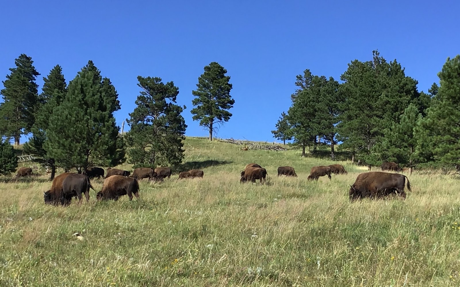
Joe and Cassie go out to look at buffalo
We wound our way along the base of the Tetons as we followed the road south to the town of Jackson. There we turned west again, and had one more hurdle to get over-- the Teton Pass at a mere 8,432 feet. We were not worried about it, because we’ve gone over lots higher passes--but not, it turns out, while towing a 3,000+ pound Jeep. Also the grade of the road on the way up (and down, for that matter) was a 10% grade, which is STEEP. We started on our way up, and soon felt very sorry for the line of cars following us-- we were chugging up the mountain in first gear! And even at that, we were not going the speed limit and the engine was really working hard. There was nothing to do about it-- there were no turnouts to let people pass until we’d been driving for perhaps 10 minutes. 

At last we came to a large turnout, and by that time we’d discussed unhitching the Jeep and driving in two separate vehicles. So when we saw the large area on the opposite side of the road, Joe turned into it, letting everyone get past us. We stopped, and looked down from this vantage point at the valley and road below us. It was SO far down there, it was no wonder that we’d had trouble getting up it--the steepness was apparent from above. So we unhitched the Jeep, and after carefully making sure we were on the same page as to our plans, I took my phone (which was virtually without any battery left), my handbag, and a walkie-talkie, and I got into the Jeep. Joe had the other walkie-talkie, and he drove ahead of me in the RV.
Looking Down from Teton Pass on the Road below
It turned out that this was a great plan, except we should have implemented it about 8,000 feet sooner. We hadn’t realized that we were almost at the peak of the pass! We soon came to a small pullout that had a lot of cars, and people looking at the view... the RV wouldn’t have fit into it, even without the Jeep. But from there, it was a downhill run. I followed Joe, making sure (via walkie-talkie-- a brilliant idea, and we could hear each other perfectly clearly) that he’d seen the road grade signs and the speed limits. We also exchanged occasional comments. And so we proceeded until we passed a “Welcome to Idaho” sign. Joe asked if I expected any more uphill climbs, and I didn’t, so when we came to a gas station, he pulled in with me behind him (he got gas while I parked on the side of the lot), and we re-connected our two vehicles.

Once we were back together, we discussed the fact that we will be encountering a number of other high mountains during the next few weeks. So we will plan to detach the Jeep at the BOTTOM, rather than when we are most of the way up, and drive the vehicles separately. Although we don’t like the idea of not being together, it’s clearly going to make it a lot easier for the RV to get over the mountain passes. I mean, we don’t even consider 8,432 feet to be that high-- last summer we went over 12,000 foot Independence Pass, a few years ago we went over the Red Mountain Pass at 11,018,  and we took Mo over the Tioga Pass (9,943 feet) to Yosemite (not once but twice!), and the Beartooth Highway at 10,900+ feet.  But the extra weight on the tail end of the RV is obviously a drag (literally)!

We still had an hour or so to drive, but the road was beautiful! To our surprise, we DID have a bit more climbing to do, but the ascent was not nearly as long nor steep as the Teton Pass had been, and we soon came into a beautiful plateau area full of golden cut wheat. This is one of my favorite “colors” on the road, and the fields just rolled away for miles, while the mountains rose up beyond them. Running beside us was the Snake River, which we discovered last year seems to be omnipresent in the state of Idaho. It is fast and beautiful in this part of the state, and we stopped at a wayside rest area to take photos of the landscape.
Looking Down at the Snake River Valley
It was only about 30 minutes from there to our campground tonight, a county park in Rigby, Idaho, with a large lake which includes a beach and campground. I had called a couple of days ago to see if they had any sites open, because of my concern about the holiday weekend, and the woman on the phone said she had one site, because she had had a cancellation that morning! So I grabbed the site for tonight and tomorrow night (I had researched the location a few months ago while planning my trip, so I had the info with me.) It is not our usual venue, being quite crowded with families and young people everywhere, and a bit noisy. On the other hand, the people next to us on either side are not very close. The campsites are on a loop road around the lake, and we are not on the “lake side” of the road, so when the sun set a little while ago and looked so nice over the lake, I couldn’t get a photo without it mostly including RVs, campers, and tents. But we are fine here--we have water and electricity, there’s plenty of room for our Jeep in our site, and we are in a suburban area. There are museums near by, and we have a LONG shopping list which must be tended to tomorrow. So museum and shopping is our current plan for the day.

Friday, August 30, 2019

Varieties of Wyoming

2019-08-30 Friday (lots of photos, but having trouble with internet, so will upload scenery photos later)

We woke up this morning with an agenda to leave our campground early, so we'd have no trouble getting to tonight's campground with plenty of time to set up our TV connections for the MSU football game. Despite a nice morning with showers and shmoozing with Beth on FaceTime, we left by 10:00, which was right on time.

We started driving west from Casper toward Lander, Wyoming, and as soon as we got out of the city, I started in with the wow wow wows again over the scenery. Wyoming really is a spectacular state-- no matter what route we've taken (and this one was new for us), it's been so beautifyl. Unfortunately, most of my photos are on my iPad, and the iPad is refusing to connect to the internet, which is not good here (more on that later.) I hope I can get the photos into the blog tomorrow, because that is what most of the blog is about!

At a little before noon, I noticed on my map that we were just about to pass a historical interpretation site called the Devil's Gap and Mormon Hand Cart site. We pulled into the area and immediately saw the Devil's Gap in the near distance--a distinct break in the rock walls ahead of us. But just as I took a few photos of that, Joe said, "Look on the side of the road!" and there were 3 antelope just looking at us! When we got too close, they started to depart, but I was able to get some photos of them.
Hand-cart replicas. Mom pulled one handle, Father pulled the other.
We ate some lunch, then got out to explore the interpretive site. There was no one there but us, although it seemed like some kind of ranch or something like that--there were quite a few buildings and several parking areas, including a large one for "trekkers" (we were not sure what that meant.) But as we wandered down the steps toward the area saying "visitor's center", a man came out to greet us. The site is run by the Church of Latter Day Saints, and he was a Mormon who was there to give information to visitors. He told us about the history of the site, and when we went into the small museum, it made everything even clearer to us.
Example of loaded handcart

In the 1850s, there were a lot of Mormons moving west to Salt Lake City. The church set up a fund to help finance this immigration, but the funds ran low because so many were coming to America to join the church out west. So Brigham Young came up with the idea that instead of having to pay for expensive large wagons and teams of animals to pull them, the people could move their belongings in small hand-carts which they pulled themselves. Small settlements were then set up along the trail, and the Mormons in Utah would send out regular supplies to the settlements, so the immigrants could have their supplies replenished every few months as they ran out.

The Martin Company set out in 1856, but unfortunately were delayed in their departure due to a lack of hand-carts-- the builders could not keep up with the demand. As a result, they left late, and missed the window of opportunity to safely complete their journey. When they arrived at the settlements, there were no supplies for them. Many of them died along the trail, and this site where we were was the area where many of them died, before finally being rescued by members of the church coming from Utah after hearing that there were two companies (there was another one 2 weeks ahead of the Martin Company) who had run out of supplies and were stranded. As our guide/host said, "This really marks the site of a disaster rather than a triumph." He said he himself was descended from survivors of this migration.

It seems that this location is a place where members of the church come to re-experience the travails of their ancestors. "Trekkers" come and head off into the surrounding hills, pulling handcarts for several days to understand better the ordeal it must have been for those in 1856. Our guide told us that 20,000 people had come during the past summer, although it is winding down now. It was all very interesting. I told Joey that this reminded me a lot of the concept of the March of the Living, that Jewish kids go on to visit the concentration camps in Europe. As our guide said, it's important not to forget your own history.

We wandered around the site for perhaps an hour before finally getting back on the road. Not long afterwards, as I was looking down, suddenly the RV swerved violently back and forth! As I looked up, I caught a glimpse of SOMETHING. I made some kind of exclamation (you can imagine what kind) and Joey said an antelope had just run across the road RIGHT in front of our RV, and he had both braked and swerved to miss it. If it had hit us and come through our windshield, we'd have been in big trouble! It was VERY scary for both of us.

After that, there were no more incidents, and we arrived in Lander at 4pm. We went into the center of town to see if there seemed to be strong wifi, because we were willing to go elsewhere if necessary. Then Joe called the campground, where they insisted that the wifi was usually pretty good at our assigned site, but if not, it was very strong at the office and we could sit there to watch our game. So we went to the campsite and checked in, but as soon as we got to our space, we didn't have any wifi or any decent internet connection.

I'll spare the details, but we spent an hour, both trying to connect via internet, and by using an app on my phone to connect to the radio network in East Lansing that broadcasts the Spartan games. Just before 5pm local (7pm EDT), we got everything working, both radio and tv. We were able to watch or listen to maybe 90% of the game, I'd say-- but the internet did keep cutting out. When the picture was lost, I'd turn on the radio. It was a little crazy, I guess, but football fans ARE a little crazy.

Joey made us dinner while we were watching, and at halftime we did give up and go sit in the patio area near the campsite office. Luckily it was an absolutely lovely, mild evening, and very nice to sit out. The game ended at 8:30 (MSU won, 28-7), and after we put our electronic paraphernalia back into the RV, we went out for ice cream in the Jeep. Then Joey went to bed, while I did the dishes and then wrote this blog. I just hope I can upload it-- the internet is really NOT what I'd prefer, that is for sure!! And I suspect it will get worse from here on, so we are probably lucky we at least saw the first game of the season. And that was the evening-- I will try to upload this, and then I am going to bed. We have a long drive tomorrow, to Idaho.

Thursday, August 29, 2019

Heading West on our 48th Anniversary

2018-08-29

Not much to write about today— we got out of our campsite at 11:15 this morning, after cleaning up and hooking up the Jeep. We had some difficulty with Cassie—she simply refused to get into the RV. She gets this cow-like look on her face, with her head held down and looking up at us at the same time, simply refusing to go up the stairs. We finally tied her up to a tree while we hooked up the Jeep, and then it was a battle of authority and she caved and got in the RV.

We drove south and then west in the Black Hills, and stopped for lunch at the parking lot in Jewel Cave National Monument. We did the exact same thing last year! After that, we drove into Wyoming, and everything went smoothly until we found ourselves in one of those construction zones where you have to wait for the flag an and the pilot car. The wait was about 20 minutes, and then we followed with a long line of cars as the pilot car led us about 5 miles going 20 or so miles/hour, back and forth through the construction and new pavement. That backed our time line up by about an hour.
The Road Ahead in Wyoming
I almost forgot— there was one thing that was really cool about today’s drive— we saw ANTELOPE at the side of the road! Here we are out west, driving through the prairie grazing land. And suddenly, there were these deer-like animals, and then I realized, they were antelope! We’ve never seen that before. Joey took the photos on his camera, because I was driving, and he hasn’t sent them to me. So I’ll have to add them later. But it was very cool.

After much discussion, we decided to splurge on a site tonight at an RV “resort” in Casper, Wyoming. After 3 nights with no electricity, our house batteries were very drained, and we couldn’t even charge our phones overnight because we didn’t want to risk draining them further. We also were essentially out of water (luckily the drinking water pump was adjacent to our site, so we were filling old water jugs with water for the past day) and we needed to dump our waste tanks. The electricity was the deciding factor, though. So we are at an expensive (for us) campground, but we are happily using up a LOT of electricity. In addition, Joe spent some time playing with our television access via our new antenna and laptop, and as I type this, I am watching the Minnesota/South Dakota State game on FS1. This makes me SO happy because, if our internet connection is good tomorrow, we will be able to watch the MSU game, which is also on FS1. So we’ve splurged for tomorrow as well, to make sure we are in a campground which has full hookups for our laptop etc.

Today was our 48th anniversary. We’ve spent a lot of anniversaries on the road! Once I remember one in Wisconsin, where we had a problem with Mo all afternoon. About 4 years ago (I think), we were in East Lansing for our anniversary. And there have been a lot of others. Today was very nice— nothing to stand out about our drive, but our campground is next to the North Platte River, and after we got here, we sat in a swing in the grass by the river, watching it flow and feeling relaxed and mellow. And that is just a fine ending to a fine day, as far as I am concerned.

Hanging Around in Hill City

Today was a lovely, leisurely day of just enjoying ourselves in a low-key kind of way. It seems that although there are oodles of things to see in the Black Hills, we may have seen the things most compelling to us (the Mammoth Site, the drive we took yesterday, Crazy Horse Monument, Deadwood, etc.) and so many of the other things are those kind of “family fun” places which are not geared for us at this point. 

So we went for the practical— we started the day with a visit to the laundromat. The place was small, but not crowded— I was able to get 3 machines right away, and by the time they were done, there was no one else using the dryers either. So I sat down with my iPad and uploaded yesterday’s blog, and tried to get my phones charged at the same time. Working on the blog made the time pass very quickly, and the dryers turned out to be very efficient also (i sure hope my clothes didn’t shrink—i put them on Low but they dried in 30 minutes, a little worrying.) In any case, I was finished at 1:00 pm. Joe and Cassie, meanwhile, were hanging out on the bench outside in the shade, people watching and talking to people who started up conversations. 
Whirligigs and lawn chotchkas

We put all the clean laundry into the Jeep, and then went to find a place on Main Street in Hill City to eat lunch. I was concerned about Cassie, though— the weather had gotten warmer than we expected. So we popped the roof off of the Jeep on the passenger side. It was heavier than I expected, so rather than take it off and try to wedge it into the front seat, we just left it up on the roof! That worked perfectly fine, and we ate right across the street from where we’d parked at the curb.

After lunch, we went back and got Cassie again. I had thought we might go to one of the small museums in Hill City, but Joe wasn’t really in the mood, and I wasn’t too excited about them either. So we wandered up and down the streets, which are full of the kind of stores you’d expect in a small, mostly touristy city— souvenirs, gifts, t-shirts, saloons (it is the Wild West, obviously), etc. But we did have to stop in first at the Beef Jerky Outlet. It was right next door to our restaurant, and Cassie was invited in with us. Joe sampled the jerky while i sampled the chocolate cordials. We both found something yummy to take with us, of course. I wandered into a couple of gift shops, but didn’t damage the bank accounts too much. Joe and Cassie sat outside and Cassie shmoozed with passers-by. We crossed the street and checked out an ice cream shop (I had Black Hills Gold flavor ice cream, which was salty caramel with cashews, pralines, and butterfingers candy. It was outstanding!) We sat on the patio in the shade and watched the people go by. It was just so relaxing! Finally, we visited a store with a lot of lawn “whirligigs” outside, and again they invited Cassie in, so we checked out the gifts as well. Hill City was very dog friendly, with a lot of blue bowls of water lining the streets for dogs to have refreshment. We really enjoyed the day.
“Iron Star” is made out of recycled metal items

We finished up with a quick trip to a local winery. I couldn’t resist going in, because they had big ads lining the road for their signature wine, “Red Ass”. I mean, they showed a donkey on the label, but REALLY? Joe stayed in the car with Cassie, while I went in for a tasting. It turned out that Red Ass was a rhubarb wine, of all things. They gave me 5 free tastes (they had a full complement of everything from dry to super sweet Concord grape), and I just did not care for the Red Ass, despite the intriguing name. So I could not in good conscience buy it as a gift for someone. I did buy another bottle of the Cabernet, which surprisingly, I really liked! We’ll see what the family’s expert thinks of South Dakota wine. 

After that, there was nothing to do but stop at the local grocery store, pick up a few things, and head back up the mountain to our campsite. I put the laundry away while Joe did some electrical things (there’s always maintenance going on around here!) and read my book. After dinner tonight, we are going out to look at the stars— there are about a gazillion stars visible from this campground and it is truly amazing so see. They were beautiful last night, and with a cloudless sky all day today, I’m sure they will be just as extraordinary tonight.

Wednesday, August 28, 2019

Getting the WOWs in Custer State Park

“Needle’s Eye” Tunnel
2019-08-27 Tuesday

It’s funny that some days driving all day can leave you just tired, and some other days of driving all day can leave you in awe (as well as tired!) Today was one of the latter. We drove all day, we are in fact quite tired, but WOW, what an awesome day!

Today was one of the days which explains why we are towing our Jeep now. We’ve been to the Black Hills three or four times already, but the one place I’ve wanted to go has been out of reach— the loop road through Custer State Park, which includes the Needles Highway and the Iron Mountain Road, both of which have tunnels through the mountains which are too small to accommodate an RV. Today, courtesy of our Jeep, we finally made it through that road.

When we woke up, it was almost COLD out! We put on jeans and sweatshirts, for the first time in months, and it felt delightful. We had breakfast, took a leisurely walk around our campground, and then we packed up our car with a picnic lunch, drinks and water, snacks, my good camera, my iPad, our car jumper, Joe’s walking stick, flashlights (you never know), phone chargers, and Cassie’s water bowl. Then, with Cassie in the back, we set out for a day’s adventures. 

We started the day at the Visitors Center in Hill City (a 25 minute drive down the mountain from our campsite). There, I asked the nice lady specifically about the drive we wanted to take. She explained where to go from the Visitor Center, and what parts of the loop were especially interesting. She also told me where the laundromat is, because that is something we’ll also be needing. And she directed me to the post office— I’ve been carrying around postcards for days, unable to find a place to mail them.
The Needles Highway

It turned out that we had a fantastic internet connection in the parking lot there. So I was able to upload my blog and the photos to go with it— both quite quickly.  Next, after dropping my postcards at the library, headed to Custer State Park. The first stop on the loop, about 6 miles along, was at Sylvan Lake. This was convenient because it had picnic tables and it was 12:30 pm. So we ate our lunch while Cassie lay in the grass nearby. After that, I ran into the gift shop, and of course managed to find a few little souvenirs. 

After we left the lake, we continued climbing and encountered the Needles and the tight tunnels through the road. The experience was extraordinary! This is one of those blogs where I am going to have to let the photos tell the story. (Speaking of which, I took most of my photos on my iPad, and that worked very well.)

The drive continued— we drove through beautiful pine forests along incredibly curvy roads (I can’t guess how many S turns and hairpin turns we made on that road. As a result, the average speed we drove was about 25 miles/hour, I’d guess, and maybe less. We stopped a lot to look at the views, too. At one pullout, we struck up a conversation with another couple about our age, who were from Virginia. We shmoozed and exchanged tips and places to visit, as well as general info (they were on their honeymoon) before setting out again.

In the Wildlife Loop Road, we encountered a herd of buffalo wallowing and digging in a muddy morass by the side of the road. Since it was on BOTH sides, they were IN the road as well. Needless to say, I took photos . Further along, we saw prairie dogs (they were too small and too far away for the iPad to get them, and my good camera was buried), and then a pair of pronghorn deer. Soon after that, we were stopped by a group of semi-tame burros, who spend their time begging for food from travelers. We didn’t feed them, but again, I took photos. And then a few miles further, we encountered yet another herd of buffalo, some right next to us. There seemed to be a large number of calves with their moms, which was sweet. 

The last section of the trip was the Iron Mountain Loop Road, which is famous for the 3 tight tunnels near Mount Rushmore. They were cut into the rock so that when you go through them, the faces of the presidents are framed at the end of the tunnel. I was looking forward to this, but alas, it was actually about 5pm, and the sun was low, and Mount Rushmore was in shade. This meant that the faces were nearly indistinguishable from the surrounding rock until we were very close later on. The tunnels were fun, however, as was the “pigtail” section of the road—a place where the road was supported by wooden structures which led from one tunnel to the next one, and as a result, turned the car about 270 degrees at each junction. It’s hard to describe, but was fun to go down. The road runs right past Mount Rushmore National Monument after that, but we were exhausted, so we headed home instead. 
100,000 miles


We got back to our RV at about 6:30 pm, I think, and we are utterly wiped out. I said to Joe, “But all we did was DRIVE!” And ironically, the loop is only 76 miles. So we didn’t even cover that much territory. But it sure was fantastic. Joe really loves that kind of driving, and there were times that we were the only ones on the road and saw no one else. The forest came down to the edge of the road, and it was beautiful and enveloping. Truly a gorgeous drive. And, as an added fun thing, our Jeep’s odometer went over 100,000 miles! We were just at a turnout when that happened, so we were able to stop and take a photo of the dashboard to commemorate the milestone.  And now, photos:


Tuesday, August 27, 2019

Badlands and Black Hills—Driving

The road ahead
2019-08-26 Monday 

We had a long day of driving ahead of us today, so we tried to get up and out early. We did a pretty good job hooking up the Jeep, despite the muddy campground— it rained last night, and the campground had a lot of standing water in the grass, and puddles in the road. It wasn’t really mud— the ground in that part of Nebraska is pretty sandy, and the road was sand under gravel. In any case, we worked around the puddles, and got out at about 9:30. 

After that, it was just a long drive! We drove west through northern Nebraska, on a road which is a “scenic highway.” It was very pretty, although it wouldn’t knock anyone’s socks off, but it is pretty in a very mellow way. Lots of bales of hay rolled up, green fields, corn, and then toward the last section, an area known as the Sandhill region (more sand, I guess!) The hills were rolling hills and pretty.

We finally turned north toward South Dakota, after stopping at a Sinclair gas station. It was a bit retro—it had a dinosaur sculpture under the gas sign. We also noticed the price of gas was going up, which I expected. Anyway, we drove 8 miles north and were suddenly in South Dakota. I had originally thought of taking I-90 so we could shorten the trip, but Google maps told me that if we drove the scenic way, it was only about 10 minutes longer. So we drove parallel to I-90 on a road which went through some National Grasslands, with quite a bit of “Badlands” thrown in, and even a section of Badlands National Park (the scenery for those couple of short miles was spectacular.) We’ve been to Badlands NP before, so we didn’t feel too bad about not going up to the main part of the park. We also crossed into Mountain Time, so we are now 2 hours behind home.
Badlands

It *was* a long drive, but eventually we got to the Black Hills area, and followed our directions to Dutchman Campground, which is 6100 feet up in the Black Hills National Forest. The road was steep,

and I was having second thoughts about being so far from all the “touristy” things we might like to do (such as our definite plans for Custer State Park and Mount Rushmore.) It took us almost 30 minutes to get up here once we left the main road. Also, when we turned off to go into the park, there was a 1.5 mile unsaved road full of potholes, which were mostly full of water. So we arrived muddy as well.

But when we got here, we weren’t sorry— it is beautiful, and Joey especially loves being up in the pine forest on top of a mountain. We stopped at the camp host’s site briefly to get a map of the sites, and then came to look for one which might be reasonably level. We found one, but the road itself is very sloped, and we needed something flatter to unhook the Jeep. So pulling forward, we successfully blocked the road and wrestled with all the muddy connections, trying to hurry because of course someone came up behind us and wanted to get past.

Eventually we managed to get it all unhooked, and just then the camp host drove up. The site we’d picked was right next to a double site (which costs double per night), but he told us we could take the double site for the single price. We also got half-price because of our America the Beautiful senior passes, so our cost was a most reasonable $12/night. We have a view of the lake below us, we are surrounded by pine trees, and the campground is only about 1/4 full. So it’s incredibly quiet and beautiful. 


On the way through Hill City (the official address of the campground where we are), I saw a Visitor Center, so we will probably go there first tomorrow. There were also a couple of wineries, and I plan to pick up a couple of bottles of the local product for my son-in-law, the wine connoisseur. After that, I have no idea what we will be doing! I will figure that out once I visit the Visitor Center and get some suggestions. I’m sure, though, that it will be a lovely day.

Sunday, August 25, 2019

12 Million Years Ago

Overview of fossil site shown on live camera
Skeletons in situ labeled
2019-08-25 Sunday

Today was one of those days when we really feel as if we found a gem that hardly anyone seems to know about. We have waited for a year to get back to Nebraska to see Ashfall Fossil Beds State Park, and today was the day. We left our campground at 9:30, for a 2.5 hour drive (which took us 3 hours, with a stop for gas and slower speed than the speed limit allows.) As soon as we got out of the outskirts of York, the scenery became more and more rural until we felt we were driving into the middle of nowhere. The towns were all tiny, with no gas stations or much of anything, really. There was only one sizable town during the entire 135 mile drive.

Adult female barrel-bodied rhino
The park itself is in a gorgeous setting of hills, ravines, and green everywhere. And SO QUIET-- when we got out of the RV in the parking lot, all you could hear was the breeze and the crickets. Standing there with the cool air blowing lightly and the green hills all around, I would have been happy to just sit and drink it in for an hour or so. But of course, I was too eager to go see the fossils.

12 million years ago, the area of Ashfall was a semi-tropic area, and there was a water hole in that spot. The area was populated by a lot of mammals which are extinct relatives of our living rhinoceros, horse, camel, dog/cat (they have the same ancestor!), and loads of smaller mammals as well as birds. At that time, a volcano erupted in what is now southwest Idaho, and the volcanic ash blew eastward, settling as it came. A significant amount of it fell in what is now the Ashfall area. The animals in the neighborhood of the water hole died in that area--first the birds and small mammals, then the medium ones, and finally the largest, the rhinos. The winds blew the volcanic ash over the dead animals before the bones could be moved by weather or by carnivorous animals, and so as the ash hardened, the bones stayed as intact skeletons. The smaller animals with less lung capacity were affected by the ash in the atmosphere sooner, and the scientists think it took 4-6 months for the largest animals to be affected. Until they died, they were breathing what was essentially toxic ash, and many of them show signs of some kind of lung disease (I’m not sure how they can tell, but apparently they can) because they were breathing it longest, and inhaling the fallen ash with the grasses which they grazed on (most of them, other than the dogs, were herbivores.)
Bird (Crane) skeleton with lizard in its stomach
Complete skeleton of 3-toed horse

Unborn baby rhino in adult female


Because the bodies were protected by the ash, which is like crushed glass in texture, tiny details of the animals were preserved. So besides the skeletons being intact, there are details such as females with unborn fetuses still inside them (it was one of these skeletons, which is on display in Lincoln, which clued us in to the Ashfall area last year.) There is also one baby with the mother which seemed to be in a position to be nursing, with its head up under the ribcage of the mother animal. It is just amazing to see so many of these large animal skeletons totally complete. They are being preserved with a cement around them, because the bones are mostly not petrified. The exteriors are hard, but the interiors can crumble, and so the bones can be easily damaged. The first large group of animals to be uncovered were removed to protect them, but now the plan is to leave them where they are found for educational purposes. The site has student interns working there in the summer, slowly uncovering more of the site (I am so jealous-- I would love to work there!) The whole set up reminds me very much of the Mammoth Site in Hot Springs, SD, which we visited back in 2007.
Cassie checks out a petrified rhino bone

Baby rhino skeleton displayed at visitor center
We looked at the displays in the small visitor center for 20 minutes or so to get oriented to what we would be seeing, but we spent most of our time in the Rhino Barn, as it is called. The rhinos are the most common animal to be found at Ashfall. They have found (I think I remember reading) about 48 females, but only 6 males, and about 48 young rhinos. They think that maybe the rhinos behaved like some other modern animals, where there is one dominant male with a “harem” of females and their babies, which would account for the gender imbalance. In the case of other animals known to have this kind of social group, young males gather in “bachelor herds”, and they have found a group of all male rhinos about 150 miles away from Ashfall which supports this theory. I remember something similar was true with the mammoths-- the find in Hot Springs was mostly adolescent males, and they think that the females drove the males out of the herd and they fell into the sinkhole where they were found.
I took a lot of photos, and Joey and I both talked to the young intern from University of Montana who was working there today. He was answering a lot of questions from other visitors (there weren’t many of us, though!) and also had been working in the dig area when we first arrived. Besides the dig area itself, there were a lot of poster-size panels on the wall with color drawings of all the animals which had been found in the area (they found over 200 skeletons in the first dig--located outside the current Rhino Barn--alone!) There were also electronic displays around the railing which showed drawings of the various skeletons, giving their descriptions and (I loved this part) the name of the volunteer or student who had found each one! They are all numbered, and the skeletons left in situ are numbered correspondingly so you can see a number in the dig area, and then look at the details of what kind of animal it is, on the electronic display.

All in all, I think we spent 3 hours at the site, including drinking in the surroundings and reading the information panels outside describing the landscape (the entire area outside is, of course, part of the area covered with ash, but that layer is not visible except just around the Rhino Barn, where the ground is dug out to allow a sidewalk to walk “through the millenia” as we descended to the ash layer.

The animals species at the site did not become extinct-- they existed in other parts of what is now Nebraska and elsewhere, where presumably the ash was not as thick. So gradually many of these animals returned the the area, and their bones have been found in layers above the ashfall layer. Gradually the climate changed, the animals evolved or became extinct, and time went on. But the unique circumstances at the Ashfall area have given an incredible opportunity to see these animals without having to piece them together from various skeletal remains. We were totally in awe of the site, and felt it was well worth driving the side roads to find it.

We left the park at 5:00 (closing time!) and drove about an hour west until we found a small public campground in the town of Atkinson. Tomorrow will be a long day driving to the Black Hills.

Saturday, August 24, 2019

Driving North

Rosh Hashanah coming to Salina, Kansas
2019-08-24 Saturday

Today was one of those days where we just needed to put the pedal to the metal and drive all day. Now that we’ve seen Natan and Ruby, our agenda is to head toward the Black Hills in South Dakota, by way of Ashfall State Park in Nebraska. We found out about Ashfall last summer when we were at the University of Nebraska State Museum, also known casually as the Elephant Museum. There, we not only had an incredible time, but we found out about Ashfall, a place where during prehistoric times, a volcanic eruption buried large numbers of extinct mammals, much like the eruption of Mt. Vesuvius destroyed Pompeii. As soon as I found out about the park (which we had driven past, more or less, the day before!) I was determined to map my next route via Nebraska again, so we could go there.

I knew it would take either a VERY long day of driving, or two days broken up, to get there from Enid, and we really don’t do long drives the way we did during our first RVing days. So, with an almost 500-mile trip, today was given up to driving as far as we possibly could before stopping.

We didn’t do too badly--we made it 350 miles today. We left Walmart at 9 a.m., but we had to get some propane first (we are running our refrigerator on propane.) We found a good-sounding place a bit north of Enid, which was fine, since that was our direction anyway. When we got there, though, we discovered that it was impossible to just drive up to the huge propane tank at the business; we would have to back in next to it. So we unhooked the jeep, which took a little longer than usual because of the angle we were at (that was our fault), and then I backed up in place. The actual propane fill took less than 5 minutes! Then it took us another 10 or so minutes to hook back up (I had to back the RV carefully toward the Jeep, to line the two vehicles up properly), and then we made a very tight U-turn to get out of the parking lot. All in all, it was at least a 30 minute stop, and so it was 10 a.m. before we left the northern outskirts of Enid.

From there, we drove. I had waked up at 5:00 this morning, so I realized my eyes were a bit tired after only an hour or so. We changed drivers, and kept on until around noon, when we stopped for gas and lunch. Then we drove another couple of hours, and stopped again, this time for a rest break. We took that off the highway, at a Walmart, because I had realized we only had two gallons of water, and I prefer to travel with a lot more than that just to be on the safe side. So that stop also turned out to be about an hour, so that we could rest. That Walmart was also where I was so surprised to be greeted by the Kedem display above! We read up on the history of Jews in Enid-- it seems that (other than Natan) there aren’t any there anymore (certainly no organized presence, that is.) So seeing this set up for Rosh Hashanah in Salina, Kansas, was a surprise. I do think Salina is larger than Enid, but still, it IS just pretty much “the middle of Kansas someplace.” 

After I shopped, I went back to the RV and while Joe snoozed, I was looking for a likely place to spend the night, and discovered that there were almost no choices. So that was how we ended up where we are-- at what amounts to a large parking lot about 100 yards from Interstate 80. The next closest campground was an hour further down the road, and that would have just been too much. Considering the extreme lack of ambience, the place does have the benefits of water and electricity, and a bizarrely designed but very hot shower. Since we needed water, like to have electricity hook-ups, and need to dump our tank in the morning, this is a fine overnight situation, despite the ugliness of the location. Also, one nice thing is that the weather has cooled down--it was overcast most of the day, and is quite comfortable at the moment.

We set ourselves up, Joey made us a steak with cauliflower and baked potatoes for dinner, I took a shower (he has crashed so he’ll have to do that tomorrow morning), and as soon as I finish this blog, I will go to bed. Tomorrow we hope to leave by 9:00 (I *really* hope!) for the last 135 miles to Ashfall Park. It doesn’t open until 11:00 a.m. anyway, so we should get there by noon or thereabouts, and after lunch have 3-4 hours to explore the fossils. Then, depending on the time and what the overnight options are, we will either head toward South Dakota, or spend the night at the state park and move on on Monday. I’m a little behind my original itinerary time line at the moment, but there are always ways to tweak the plans, so I’m not worried about it.

The Oklahoma Hills


2019-08-23 Friday
On Thursday night when I fell sound asleep, it was just starting to rain a little bit. But it quickly began to pour cats and dogs, with a lot of lighting and thunder. The rain, as well as the sound effects, kept up all night--once a VERY loud crack of thunder immediately above us woke me up out of a sound sleep with a cry of alarm! Poor Cassie was miserably squashed between the bed and the wall all night, and the rain just kept coming and coming. The fact that there was what appeared to be a tornado shelter right behind the casino was not reassuring! However, we made it through the night, and it kept pouring through breakfast. Joe finally had to walk Cassie in the rain as well before we pulled out.

One very cute thing happened on the drive. We took a toll road for about 2/3 of the way, and as we went through one of the toll booths, the attendant asked us, “Do you need a receipt?” Joey said, “No thanks.” The attendant, who must have been looking into our RV, said, “How about a dog biscuit?” We laughed and said sure, and she handed over a dog biscuit for Cassie, who was sitting between Joe and I looking through the front window as she often does. We thought that was so sweet, and she of course loved her biscuit!

We drove for about two hours to Tulsa, Oklahoma, where the weather app had reassured me that at noon the rain would stop. Amazingly, it did, right on the stroke of noon, which was when we arrived in downtown Tulsa, trying to find the Woody Guthrie Center, and a place to park a 44' long vehicle (us, including the Jeep.) It turned out that the Google directions were entirely wrong, which I found out by calling the center and talking to the nice young man at the front desk. He recommended we drive past the door, and he’d run out and point to the direction where he thought we could park (all the blocks immediately around the Center had metered parking.)

So that’s what we did, and we were able to park about 4 blocks away, on the other side of the interstate, where the metered parking left off. We left the RV in an empty gravel “lot”, with the only nearby establishment being the Salvation Army facilities. Our instincts told us that it should be okay, however, so we had some lunch and then walked to the Woody Guthrie Center. This is a small museum, but it contains a lot of information about Woody’s life. There is a lot of memorabilia, videos describing the Dustbowl experience (including a virtual reality headset to put on, where we listened to a description of the Black Sunday cloud in April of 1935 which was so intense that it felt as if the world was ending. That room included a display where you could listen to Woody’s Dustbowl Ballads while reading some of the information. There was a lot of information about his life, from when he was growing up through his decline due to Huntington’s Disease, and his life in the sanitorium in New Jersey. There was also a lot about his writing and art, including many examples of his sketches and what would now be considered political cartoons, I guess. The center of the museum includes the handwritten copy of Woody’s lyrics to “This Land is Your Land,” plus a touch-screen about the song, including examples of about a dozen other singers from Arlo Guthrie to Annette Funicello singing the song.
The museum also has a temporary gallery, and the special show in honor Arlo Guthrie’s 50th anniversary of singing at Woodstock was featured. That room was fun, too-- it shows movies and videos in one corner, with the sound of them playing throughout the room as a background to perusing the memorabilia. It includes Marjorie Guthrie’s personal scrapbook of Arlo’s accomplishments, Woody’s hand-written birth announcement to some friends when Arlo was born, the guitar he played at Woodstock, and lots of information about his own writing and social justice activities.
Pages from Marjorie Guthrie's scrapbook about Arlo

It took us about 2 hours to “do” the museum (i could have listened to a lot more music, yet again--these music museums can really make you want to keep listening). After a brief sojourn in the gift shop (we have GOT to stay away from these!), we walked back to the RV, which was still safely where we left it. We had a quick snack, then hit the road for Enid, Oklahoma.

We got to Enid a little before 6pm, and after filling up with gas and trying unsuccessfully to buy propane at both Pilot and Love’s, we stopped for the night at the local Walmart. About 15 minutes later, our godson Natan and his wife Ruby pulled up to our RV. Natan is stationed in Enid in the Air Force, taking his pilot’s training. The four of us went to dinner at a local Italian restaurant, where we got to catch up with their experiences in the fairly unexciting city of Enid. The city, while being fairly large by Oklahoma standards, is not very interesting for them, but they appear quite happy, and it was great to see them. It was only 5 minutes after they dropped us back at the RV, however, when I realized we’d forgotten to take a photo of them, or of the four of us together! What a stupid oversight... it was the one thing I meant to be sure and do.

Arlo Guthrie Memorabilia