Sunday, September 6, 2015

Getting Out of Dodge


September 3, 2015(more photos to come)

We woke up this morning in the Walmart parking lot, and tried not to spend too much extra time there. We headed for the Boot Hill Museum and Front Street just after 9am, and drove the few blocks through town. We were surprised to be driving on streets paved with bricks—we learned at the museum that Dodge City has a LOT of streets paved this way.

The museum consists of about 30 buildings, some of which are original buildings, and most of which are replicas of the original buildings in Dodge City, copied carefully from photographs. It was remarkably well done and we were there for a couple of hours altogether. We entered the Museum through the Great Western Hotel, which contained the ticket office and the gift shop, plus a small movie room where we watched a short video about the history of Dodge City. From there, we walked upstairs and out of the building onto the top of Boot Hill, where “they were buried with their boots on.” There are no actual graves there anymore (the bodies were moved when the town expanded), but there was information about a number of people who HAD been buried there. No one died of old age—most of them were shot in brawls.
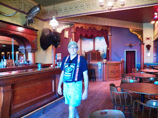
Joe in the Long Branch Saloon.

Next we went into a building containing exhibits called “People of the Plains.” This had displays about the Native Americans who first lived in Kansas, tributes to the soldiers, the buffalo hunters, and the railroad, a collection of Victorian clothing, a tribute to the early settlers, and a portrayal of Dodge City’s influence on Hollywood, including a 1950s living room with a period tv playing “Gunsmoke”.

The rest of the museum consisted of buildings along what was then Front Street. Inside all of them were exhibits corresponding with the type of business it had been. In the General Store, several types of items were for sale (for real, I mean!) and in the Long Branch Saloon, we could buy drinks. The lady running the saloon told us a bit about it, including the fact that one of the owners came from Long Branch, NJ, which is where it got its name.  We continued from the saloon through the backs of all the buildings. In Morris Collar’s Dry Good Store, we saw the types of ready-made clothing and the dress making items the shop would have had. The “Tonsorial Parlor” had barbers’ chairs; the gunsmith’s shop had a collection of firearms, the Dodge City Jail had displays about many of the more disreputable citizens of Dodge, including information about the “soiled doves” who lived there. There was a Drug Store, a newspaper office, a boot shop, the State Bank, and the undertaker’s supplies. All of these buildings housed collections appropriate to the period, as well as a lot of information about the individual lives of the particular citizens who lived in town—we learned their names, where they came from, and what they were like. It was really quite fascinating.
Tonsorial Shop

There were additional buildings as well—the one room schoolhouse, the blacksmith shop, the Hardesty House (which we wandered through to see what life was like at home for one of Dodge’s wealthiest citizens), and the First Union Church. In the church, there was a display about all of the religious groups in Dodge. That was where we found out that in the 1880s, a Passover seder was held at the home of Morris Collar, the dry goods merchant, and that “a good number” of citizens had celebrated the Jewish New Year. 

When we finally finished at the museum, it was lunchtime, so we ate before hitting the road and “getting the hell out of Dodge.” The rest of the afternoon, until just about 4pm, we drove through Kansas countryside—flat, and fairly uninteresting. After about an hour or so, we finally got to I-70, and even the diversion of small town main streets, which had slowed us but provided local interest, was ended.
Front Street Restoration (the original was destroyed by fire)
Then suddenly I saw a billboard—“Visit the Oz Museum.” I looked it up, and discovered that in about an hour, we would be passing the exit for Wamego, KS, where there is a museum containing a lot of memorabilia and information about The Wizard of Oz—both the books and the movie(s). The reviews on TripAdvisor etc were very good, so we decided to stop there. The museum was open until 6:00pm, but we didn’t make it there until about 5:20. We jumped out of the rv as fast as we could and rushed into the museum.
We entered the Land of Oz through the farmhouse door

We realized within 5 minutes that we could have easily spent several hours there—it was so full of fascinating stuff! I myself tried to spend less time looking at all the Oz memorabilia that had been marketed (just like popular books and movies end up today with everything from lunch boxes to board games and “Oz peanut butter”) and ignored the life-size replicas of Dorothy and all her friends. Instead, I focused on the information about Frank L. Baum and his books, and details about the making of the 1939 movie. There were 3 films to watch (including one from the Smithsonian), and I only caught snippets of the first two. I finally spent the most time with the one detailing what went into making the original movie. The full-length movie itself plays in the theater in the back of the museum, but I totally ignored that, since of course I’ve seen it many times. The snippets in the display films made it so tantalizing to want to watch again, however.

One really amazing tidbit of information: At some point, Frank Morgan, who played the Wizard, found a jacket which he thought was perfect for Professor Marvel (one of his alternate characters) to wear. It wasn’t until later that he noticed that inside, there was a label which said “Frank L Baum.” He was able to confirm with Baum’s widow and tailer that the jacket had, indeed, belonged to the author of the original Oz books!

The exhibits included posters, features on the lives of all the actors, toys and dolls, and at one point, we walked through a replica of the Haunted Forest—it was VERY well done and VERY spooky, along with the sign at the beginning, “I’d turn back if I were you!” The very end of the museum had cases devoted to other versions of the story (“The Wiz”, “Wicked”) but I really didn’t look at them either. At about 6:10, the woman who had let us in came to tell us that she really did have to turn off the videos and lock up the museum. We had to skip the gift shop, which had what looked like some wonderful Oz-themed goodies. The second most frustrating thing for me—after the fact that we had to look at everything so quickly—was that I had left my camera in the rv and my phone was completely dead. So I didn’t take ANY photos inside, even though invited to by the docent. I didn’t want to spare the 5 (or fewer) minutes to run back outside and get the camera! (I borrowed photos from the internet to illustrate this blog.)

So we left saying we would go back again next time we pass through Kansas. I actually considered finding a campground nearby and going back tomorrow! But instead, we got back on the road for about an hour more before getting off at Lawrence (home of the University of Kansas) and finding our way to Clinton Lake State Park. We are parked in a nice campsite, not too close to anyone, with electricity (air conditioning!) and water. Both utilities are much appreciated—we were very low on water, and it was up in the 90s again today—we would have been pretty warm without the AC. And, tomorrow morning we’ll use the showers—it’s been a while J The only thing we are missing is wifi—maybe tomorrow I’ll find another Walmart, or maybe I’ll try using my cell phone. I don’t have a huge amount of “bars” here and I’m tired, or I might try using it tonight as a hot spot. That’s a trick I haven’t used yet this vacation.

So…. I can’t actually say “it looks like we’re not in Kansas anymore” yet—but we are only about 45 miles from the Missouri state line now, and most likely tomorrow night we will be in Illinois or Indiana. Unless, of course, an unexpected tourist opportunity comes up like it did today.

Wednesday, September 2, 2015

Sand Sand Sand and Driving Driving Driving


September 2, 2015

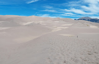
We had a lovely night in our National Park campsite, and woke up to a stunning morning view of the Great Sand Dunes and the Sangre de Cristo Mountains behind them. We first stopped at the Visitor’s Center to watch an informative film on the sand dunes, which Joe had been puzzling over all night. He said he just “could not understand what they were DOING there!”
View from our Campsite
The film explained that the sand comes from the San Juan Mountains to the west of them, and the sand then piles up at the foot of the Sangre de Cristo Mountains. After listening to the film, Joe said, “I don’t believe it.” LOL!

The thing is, the dunes are so impressive that it’s hard to understand how they COULD come to be there, so far from any other sand. We left the Visitors Center and went to the parking lot which is the access point for the dunes. There we walked through the Medano Creek, which is a wide torrent in the spring, but today was a wide collection of rivulets, some of them surprisingly fast moving. I tried to avoid getting my sneakers wet by jumping over one of them, and fell down into the wet sand. Luckily, I wasn’t hurt.

Joe in Medano Creek
We walked out onto the sand “plain” which stretches at the feet of the dunes themselves, and about 100 yards in, Joe announced, “See those people up there on the dunes? They are CRAZY!” I asked him why, and he said, “This is really hard to walk in, and I am NOT HAVING FUN.” So I left him on the plain, and I went on alone, determined to climb at least one of the lower dunes.

The sand was not too easy to walk on, but it was a little bit easier than the last time I tried walking on the sand at Sandy Hook in NJ. Also, I was thankful that it was not terribly hot today, and there was a nice breeze blowing. So I wasn’t miserable from the heat, I just had to push ahead until I found myself on top of the first dune. It was not terribly high—maybe 30 feet? I have no idea! But it  gave me an elevated view, and I could see that to go any higher, I would have to first descend my dune and climb up the next larger one. 
On top of a dune

I wasn’t really interested in going further—I’m sure experienced hikers get a sense of accomplishment getting up there, but really, climbing on sand is HARD! So I asked someone who was also content to stop at that point if she would take my photo to prove I made it up there. And then I trudged back to Joe. I had noticed he was actually lying down waiting for me, and I was a little bit concerned. But he said it was just more comfortable that way, pointing out that people lie on the beach all the time.

As we returned to the car, I took my shoes off to cross Medano Creek this time. It was lovely—cool but not cold, and a lot easier than worrying about my sneakers getting wet. On the way, Joe told me he’d figured out why the dunes were there: he said it was God’s storage spot for beach sand. He just hadn’t used it all up when He made all the beaches, this was the leftover sand. It made as much sense as the story they told us in the visitors center video!

After that, our day was all about driving. Until I really looked at the map, I didn’t realize that the Sand Dunes are actually almost exactly in the center of southern Colorado—not toward the east as I’d been thinking. We drove a LONG way today, through about half of Colorado and on into Kansas.
Once we went over the last of the mountain passes, about an hour or so after we left the sand dunes, the landscape was prairie grasslands. This has its own beauty to us, and we didn’t mind the change of scene so much…. But we minded the drop in altitude. We were at over 8,000 feet this morning, and we have dropped down to about 2600 feet (I know this because on this trip, Joe installed an altimeter app on my phone.) The drop in elevation has caused us to return to temperatures well into the 90’s. Luckily we have air conditioning in Sam.

The road less traveled
I did make one stop, feeling kind of silly about it, but I couldn’t resist. We passed two places in Fort Garland, CO, which were legally selling marijuana. One said on its sign that it was only for medicinal use, but the large purple building we passed, called Green World, announced very clearly that it was for recreational use. As I walked around to take a photo of the sign, a customer leaving the store greeted me. He looked about my age, long gray hair…. an “aging hippie” like me and the rest of my friends. I didn’t go inside—since I was crossing the border in a short time, it wouldn’t have been legal to bring home a souvenir, and I didn’t want to get high and be unable to help with the driving. But I must say, it is great to see this social change happening—one state down, 49 to go!

Legal Weed
We aimed for Dodge City, Kansas, which was (I thought) kind of a long drive, but really there were very few options for places to stop before now. Our route took us on CO 10 until we joined US 50… for most of the time, the road was very sparsely traveled. Unfortunately, the RV park we wanted to stay at closed at 8pm, and the lady told us we couldn’t come (I called at about 8:07.) The only other park I could find in my books didn’t answer the phone. So we are staying at Chez Walmart. I can’t really complain, however—the price is right, and it comes with wifi. 

Tomorrow, our plan is to visit Dodge City’s museum, built on Boot Hill, and find out all about this formerly wild frontier town on the Santa Fe Trail (which we’ve been following today, along the Arkansas River.)  And then we will continue on east.

It’s All Downhill from Here


Day 13, September 1, 2015

I was the last one awake this morning—Joe was up early, and it wasn’t until I heard Naama and Ben outside that I finally got up—it was already 9 a.m.! It got COLD last night—we needed an extra blanket, and Joe put the heater on before I got out of bed. It was 45 degrees outside and 55 degrees inside before that! But that’s why we came up here—to get away from the heat. It actually warmed up quite comfortably an hour or so later.

Joe was making biscuits before the rest of us were up and moving, so once again we at inside Sam—this time biscuits, scrambled eggs, and coffee/tea/milk. Naama was really quite enamoured of the RV by the end of our visit, but rather than agree to come home with us, she suggested that “RVs are for sharing,” which is a 3-year-old code which was very obvious to all of us. We cleaned up from breakfast, and then went for a walk to the end of the campground to the creek. It is really quite lovely, and as Joe said, the kind of place where, between the ages of 7 and 17, you couldn’t have kept him out of it! But finally it was time for Joe and I to leave and start heading east again. Ben, Miriam, Naama and Yael are lucky enough to not have to be home (in Denver) until about a week from now.

Reservoir
So we all hugged goodbye, and Joe and I headed back up the 15 miles of unpaved road. The drive seemed a little faster this time. Our ultimate goal for today was Great Sand Dunes National Park—we skipped seeing the Black Canyon of the Gunnison so that we could spend the time with our friends instead, and it was WELL worth it! I had gone over the map with both Ben and Miriam. There were three possible routes to take, but one turned off before the town of Gunnison. We felt we ought to buy gas before heading over more mountain roads, so we decided not to backtrack and headed east on US 50. We stopped at Curecanti National Recreation Area for lunch—it is a beautiful reservoir which goes on for miles, and we drove along its length after lunch. US 50 also took us over the Continental Divide at Monarch Pass, which is 11,312 feet. We stopped at the top, where there was a souvenir shop and a tramway to the top of the mountain.
It's all downhill from here!
In the end, however, although we were up there for quite a while (Joe needed a break from driving on the winding roads and I was in the gift shop, of course!), we skipped the tram before we finally headed “downhill” at about 4:45 pm.
   
After that we drove as quickly as we could south on US 285 and CO 17 (one of the emptiest roads we’ve traveled recently) until we reached the county road east toward Great Sand Dunes. We could see them for a quite a while, at the foot of the Sangre de Christo Mountains. We could also see what looked like a huge rainstorm over the mountains to the west of us as we drove through the valley. By the time we got to the park itself,
View at the Continental Divide
there were some clouds and the sun was starting to set. We got ourselves into a campsite in
the national park at 7:15, not long before the red of the sunset came through the rainstorm to the west.
Sand Dunes in the distance, at Dusk
Now we’re camped with a great view of the Great Sand Dunes. The campground is surprisingly full (although not completely), and the rain finally arrived here, although it’s not too heavy.  We are hoping to get an early start tomorrow and explore the park for a while before continuing on our way. We had sporadic cell service today, and of course absolutely none at Big Cimarron Campground last night, so it will be another day before I get this blog caught up on line.
Storm in the Distance

Friends in High Places


August 31, 2015

The title of this blog is NOT a pun on the fact that Colorado now allows the legal purchase and consumption of marijuana, although it is true that today, Joe and I drove through Ridgeway, CO, and there were TWO “dispensaries” with large signs advertising the finest cannabis in the area. In neon. Unfortunately, Joe was driving and we zoomed past the stores (which were opposite each other on Route 550, the only road through town) before I could say “Stop—I need to take a photograph!” So you will have to take my word for it.

Rather, the title refers to spending time with our friends at fairly substantial elevations in the mountains. Joe and I woke up on Monday morning and, after handling all the household and personal tasks necessary before leaving such a civilized campground (full hookups, hot showers, etc), we pulled out of our Ouray campsite at exactly 11:00 a.m.  Two blocks later, I jumped out of Sam and, while Joe drove around the block, I went into Mouse’s Chocolates on the corner to buy cookies. Ben and Miriam had mentioned that Mouse’s Chocolates, where I had gotten ice cream the day before, makes these wonderful cookies called “scrap cookies.” They take all the little scraps of candies left over from their chocolate making, and toss them all into cookie dough. Each cookie is different, and each bite is different, since you never know what you might encounter—chocolate, toffee, caramel, etc. So I bought a half-dozen cookies to bring up to Big Cimarron Campground with us.
Colorado Scenery

We drove north on Highway 550, through Ridgeway (as mentioned above) to Montrose. Montrose is a quite large town—it has both a Walmart AND a Target, lots of other stores, restaurants, etc. You can get anything you need—it’s obviously the center of civilization for the other small towns in the area. We stopped first at a Radio Shack, where Joe found exactly the soldering iron he’d been looking for (he had been trying to repair our tire pressure monitor, and the soldering iron he had was not adequate.) Then we went to Walmart, where we purchased a lot of non-food items for some small repairs, maintenance, upgrades, etc. we wanted to make in the RV, and then more veggies, water, milk, and ice cream. By the time we finished, we were VERY hungry, so we had some sandwiches.  Oh yes, we also spent about 10-15 minutes chatting with another RVing couple in the Walmart parking lot about their towing set up—they have a big Class A and are towing a Jeep, and they had the very set-up that Joe had researched and thought was best. As a result of all these diversions, it was after 2pm by the time we left Montrose and began to look for the Big Cimarron Campground.

Panoramic view of Big Cimarron Road
It was fortunate that I had already put the info into my google maps and paid attention to it ahead of time, because about 10 or so miles outside of Montrose, we no longer had cell reception. We kept an eye on the odometer, and we did not miss our turnoff, which was a 15-mile long unpaved road. It was very pretty, and there was almost no one on it other than cows and horses—we hardly saw another vehicle. We did pass the entrance to a lot of ranches, and the scenery was beautiful, but we were just a LITTLE worried that we might miss the campground itself. According to the map, however, the road was going to end soon—I figured the worst that could happen was we’d have to go back up to the main road and figure out where the heck we were. We were still keeping track with the odometer (there were no helpful signs) when we suddenly came to a National Forest sign with some campground arrows, and right behind it was the entrance to a camping area. We drove in, and stopped, wondering if this was the place, when suddenly Isis and Ben appeared around the bend in the road ahead. We had made it!

We parked Sam in a fairly level and grassy spot across the road from the kids—they were literally the only ones camping there until we arrived. We all hugged and said hello, and then they went to finish collecting firewood (which they’d been doing when we arrived), and Joe did some of the little chores which our Walmart stop had enabled him to finish. I was just about to start reading my book, when a small person appeared outside our RV door. So I went with Naama to “her campsite”, and sat chatting with Miriam and Ben (who also made a campfire).  I surprised them with the “scrap cookies” and with a couple of bottles of soap bubbles we’d brought for Naama—Ben said he was sending us psychic brain-waves to bring both of them! We also experimented with letting Cassie off her leash—Isis and Sampson were both running around free the entire time. It turned out they were better behaved than Cassie, who became so overexcited by chasing something that she briefly disappeared.  She ran back to me only a minute or so later, but we turn out to be worry-wart parents, and we told her she was going to be a leashed dog the rest of the time.  She did like being with the other dogs, I think, though.
Dinnertime

At about 6, we all decided it was time for dinner. After a brief consult, we agreed on macaroni and cheese. Luckily we’d picked up those veggies earlier—Joe made curried stir-fried vegetables and rice as well as the mac and cheese. We sat outside at our picnic table and managed to finish the entire 1 pound of mac and cheese as well as most of the vegetables. Naama and Yael really packed the macaroni away! We were very impressed with their appetites, although I have to say none of us actually starved. There was very little left over.

While Joe washed the dishes, we all sat in the RV together, trying to convince Naama that she wanted to leave it and show us “her” tent. However, she wasn’t too convinced. Sampson wasn’t too eager either—he came inside the RV and experimented with every good dog spot. He tried napping on the floor between the two front seats, in the navigator seat (mine), and under the table. He really was quite happy inside and was unenthusiastic about leaving (Cassie, meanwhile, was outside with Isis). We finally got both Naama and Sampson out of the RV and over to their campsite, where Naama made shadow puppet hands while Ben held the flashlight for her. I finally decided I was ready to lie down (Joe was already in bed finishing his book), and we said goodnight. We still had the entire campground to ourselves.